On the way down to Austin, Texas to set my art bench at the Leander Public Library, I noticed signs for 3 different archaeological parks in Arkansas. I picked Toltec Mounds as my side trip adventure for this voyage. It's located a short distance east of Little Rock - signs from 440 take you right there.
The first thing that I encountered was the interpretive center / museum, which is a beautiful piece of architecture. I ended up in a lengthy conversation with the Park Superintendent, Stewart Carlton. The highlight of that conversation was learning about an experimental type of deep scan that had been done on the mounds. I'm a big fan of Geophysical surveys as it can give "the big picture" of an archaeological site. Scans can show features that even an experienced eye could miss in a dig (and you don't have to tear up the whole place while doing it!). Stewart Carlton set up my own 1-man private viewing of their presentation video in the museum and then I got to wander through the museum and the grounds at my own speed. How cool is that?!An enormous amount of awesome artifacts have been found at the complex over the last 150 years. My eye was caught by these delicate Novaculite arrow points.
There were raw pieces of Novaculite in the outside landscaping. This stone is a fine-grain Quartzite that's a nightmare to work until it's been heat-treated.
… and how about these pretty points made from clear crystal. Of course, Arkansas has some of the biggest and best Quartz crystals to be found on this planet. My rock collection has many examples from the Mt. Ida area.
This map shows the 1.6 mile trail through the mound complex. This was my 4th day bouncing down the highways in the big truck; I needed the break to stretch my legs. It was pleasant to hear bird song instead of the roar of the diesel engine.
The whole site had been ringed with a moat and embankment. However, decades of farming had knocked the high places down and filled in the low places. I'm happy that the State of Arkansas has the vision to preserve important sites like this from further deterioration.
That red box and a ring of flags shows where Mound H used to be located. From the top of the largest Mound A, the sun appeared to rise over this mound on the Equinoxes. But... it gets weirder than that... it was backwards when it came time for the sun to set. You would stand on Mound H and watch it set over Mound A. From Mound E, the celestial north (Polaris) always appears above Mound A.
This is mound B where the Summer Solstice sun appears to rise as seen from Mound A. The Summer Solstice sun appears to set over this mound as seen from Mound H. So, these 3 mounds in particular had a very complex relationship
The bigger mounds A and B are adjacent to an oxbow lake. This walkway takes you out to the water's edge.
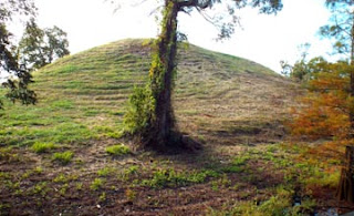
This is the waterfront side of Mound A which is the major focal point for the whole complex. It's hard to get a sense of scale, but the mound is almost as high as a 5 story building. It would be nice if they could install a set of steps (like at Cahokia) and maybe a platform on the top (since they don't want people actually on the mound itself) so that visitors could get a sense of things. From that height, the whole complex would be much more impressive. I think it would be nice if we could see what the original builders meant to be seen.
All along the waterfront are large Cypress with these sculptural "knees".
I found my trip to Toltec Mounds enjoyable and thought-provoking. I'm saving the best for last: they found that the arrangement and sizes of the mounds and plazas were laid out with a system of measurement equivalent to 155.8 feet (47.5 meters). I'd never heard of a system of measurement in ancient Native American sites. Is this singular to this place or can that be found elsewhere such as Cahokia or some of the mound complexes in Ohio? There's plenty of mysteries left to be solved about the people who lived in the U.S. long before we came on the scene.... and the truth would probably blow our minds!


